Underground drones for emergency response: investigating a sinkhole
Underground Drones for Emergency Response: Investigating a Sinkhole in Lyon
In a recent emergency in Lyon, the Elios 3 drone was deployed to investigate a mysterious sinkhole that had appeared underground. This advanced technology provided a safe and efficient way to gather critical information about the site.
Key Benefits at a Glance
|
Access Without the Elios 3, it would have been nearly impossible to get a clear view of the underground space that had collapsed. The drone allowed inspectors to see what was hidden beneath the surface without risking human lives. |
Speed The Elios 3 completed its flight in just minutes, delivering crucial data quickly and allowing authorities to act with confidence. |
|
Safety The sinkhole posed a serious risk to nearby residents and emergency responders. By using the Elios 3, they avoided putting people in harm’s way while still gathering essential information. |
Data Quality The LiDAR scan from the Elios 3 helped determine if the cavern threatened the foundations of nearby buildings, offering detailed insights that traditional methods couldn’t provide. |
Lyon has a rich history that dates back to ancient times, when it was known as Lugdunum, a Roman city founded in 43 BC. Today, the city is famous for its historical landmarks like the Théâtres Romains de Fourvière and the Jardin Archéologique. However, beneath the modern streets lie remnants of the past—Roman ruins, old sewers, and forgotten structures. These hidden elements can sometimes cause unexpected issues, such as sinkholes, which require careful monitoring to protect public safety.
Local Authorities Turn to Drone Technology for Emergency Response
In a residential area of Lyon, a large sinkhole suddenly appeared near an apartment building. The Lyon Metropole quickly realized the potential danger—if the hole expanded, it could threaten the structure above. To assess the situation, they turned to Xenodrone, a company specializing in inspection services. Julien Gay, the head of Xenodrone, who previously worked as a firefighter, knew the urgency of the situation and believed the Elios 3 was the best tool for the job.
The sinkhole was close to a residential building, increasing concerns about the size and nature of the sinkhole
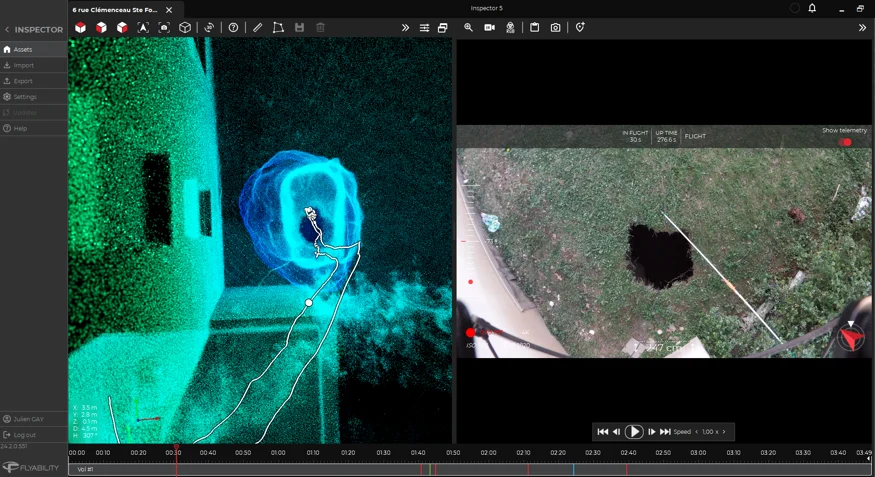
Julien arrived on-site and found a hole just 2.5 meters away from the building wall. Given the proximity to Roman structures, he suspected the cavity might be part of an underground network. Without a drone, it would have been extremely risky to approach the site directly. Using the Elios 3, he could safely explore the area and collect the necessary data without endangering anyone.
The Elios 3 entered the sinkhole without anyone having to go near it, keeping emergency response staff safe
Julien's mission was to determine if the sinkhole posed an immediate threat and whether it was expanding toward the building. He used the Elios 3 to perform a LiDAR scan, creating a 3D model of the cavern. In just four minutes, he gathered enough data to understand the depth and layout of the space. The results showed that the cavity extended six meters deep, raising concerns about the stability of the surrounding structures.
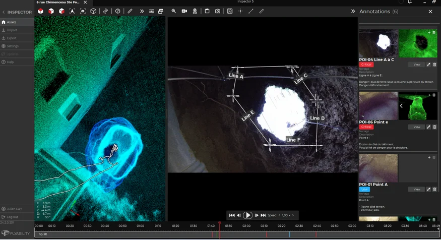
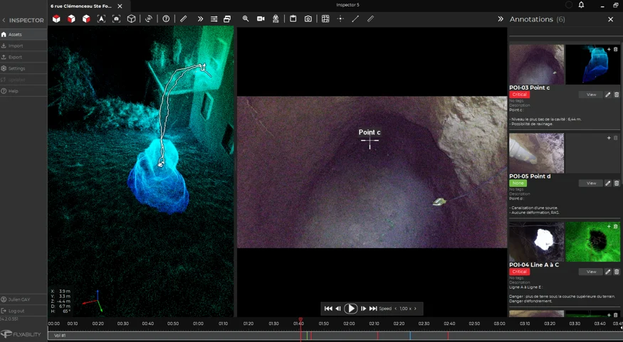
As part of the report, Julien helped responders analyze the proximity of the cavern to the building foundations
Once back at his office, Julien compiled a detailed report using Inspector 5, providing local authorities with clear insights into the risks. The LiDAR data helped them assess the potential damage to nearby buildings, while the visual data gave a clearer picture of what lay inside the sinkhole. Was it a natural formation or a remnant of the Roman era? The answers were critical for future planning.
The Flexibility of the Elios 3 Powers Emergency Response
When dealing with unpredictable situations like sinkholes, time is of the essence. The Elios 3 proved to be an invaluable tool, offering rapid and accurate data collection without compromising safety. A quick 4-minute flight provided insights that would have been impossible to obtain through traditional means. More importantly, it kept emergency personnel out of harm’s way, giving them peace of mind during a high-stakes operation.
Julien noted that this mission significantly boosted confidence in using drones for emergency response. “As a former firefighter, I’ve seen how critical speed and accuracy are in these situations. With the Elios 3, we can now respond faster and more effectively than ever before.†Since the incident, Julien’s report helped identify a hidden spring beneath the sinkhole, which was filled with 63 cubic meters of material to stabilize the ground. Now, local authorities have a clearer understanding of the subsidence and can plan accordingly.
What makes the Elios 3 even more valuable is its ability to return to the site for follow-up inspections. If the terrain shifts, new data can be collected and overlaid with previous scans to track changes over time. This predictive capability helps authorities anticipate future risks and take proactive measures.
Thanks to the Elios 3, Julien not only provided critical data but also demonstrated the power of drone technology in emergency scenarios. His work highlighted the importance of innovation in public safety and set a new standard for how cities like Lyon handle unexpected geological challenges. With tools like the Elios 3, the future of emergency response is safer, smarter, and more efficient.
Food Label,Food Product Label,Ingredients Label,Food Date Labels
Jiangmen Hengyuan Label Technology Co., Ltd , https://www.jmhylabels.com